Shipwrecks can trigger a suite of sentiments. In some instances, they can be sobering reminders of misfortune, loss, and vulnerability. Under other circumstances, wrecks are amazing as they can give incredible insights into historical events and cultures. This story about a shipwreck in Auckland and Northland’s ‘blue backyard’ is both fascinating and worrisome – a conundrum from a heritage and environmental management perspective.
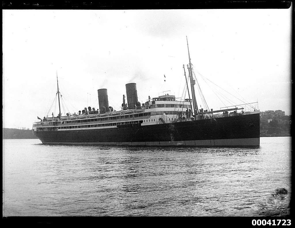
The Queen of the Pacific
Royal Mail Ship Niagara was a transpacific steam ocean liner, and refrigerated cargo ship, launched on 17 August 1912 in Scotland. She was built for the Australia-Vancouver service by way of New Zealand, Fiji, and Hawaii. The Niagara was the first oil-burning steam ship certified by the board of trade to carry passengers, initially owned by the New Zealand Union Steam Ship Company.
Back in 1913 she was an impressive, luxurious vessel, the “largest and finest ship ever to enter New Zealand waters.” and earned the nicknamed “The Titanic of the Pacific” even before her launch. After the real RMS Titanic sank in April 1912 her new nickname became “The Queen of the Pacific”. In her eventful 27-year career, the reliable ship set speed records and made 162 round trips between Australia, New Zealand and Canada – nearly 2,500,000 nautical miles (4.6 million km).
The fate of the Niagara
RMS Niagara was the first Pacific shipping casualty of World War II sunk by enemy action when she struck a moored contact mine off Bream Head, between the Mokohinau Islands and the Hen and Chicks, during the early hours of the morning on the 19th of June 1940. The mine was just one of 228 which were laid across the mouth of the Hauraki Gulf by the German Navy’s auxiliary cruiser Orion in an effort to blockade Auckland. Luckily, all of the crew and passengers onboard got away safely on a fleet of 18 lifeboats. The wreck of the Niagara rests at the northern boundary of the Hauraki Gulf Marine Park at a depth of 121m (405ft).
Carrying curious cargo
When she was first sunk, news headlines focused on the significant amount of valuable cargo onboard which included; a large collection of small arms ammunition and a secretly stashed 590 gold bars in the ships ‘strong room’. The 8 1⁄2 tonnes of gold was payment intended for the Americans, from the Bank of England in exchange for weapons being supplied to the UK. A risky salvage operation to retrieve the gold bars started in December 1940 and a year later two crews had recovered all but five of the gold bars. To retrieve the gold ingots from the ships ‘strong room’, explosives were used to blast holes in the hull, causing further damage to the wreck and releasing unknown quantities of oil.
The Niagara had the capacity to carry 5,000 tonnes of fuel and the vessel was only recently leaving Auckland’s port with a full bunker of oil when she encountered the mine. Reportedly, oil has been escaping from the wreck ever since she sunk but questions as to how much fuel is still within the ship have been largely unanswered. It is highly likely there is still a lot of heavy fuel oil stored within the ship’s bunkers, 82 years on from the sinking of the vessel. Various reports estimate the amount to be over 1,000 tonnes – for context, it’s likely to be a much larger volume than what was released into the marine environment when the Rena hit Astrolabe reef in 2011, most of the fuel on that ship was recovered before she sank. An estimated 350 tonnes was what was dispersed into the sea, leading to what is considered by many New Zaland’s ‘worst maritime environmental disaster.’
What we know
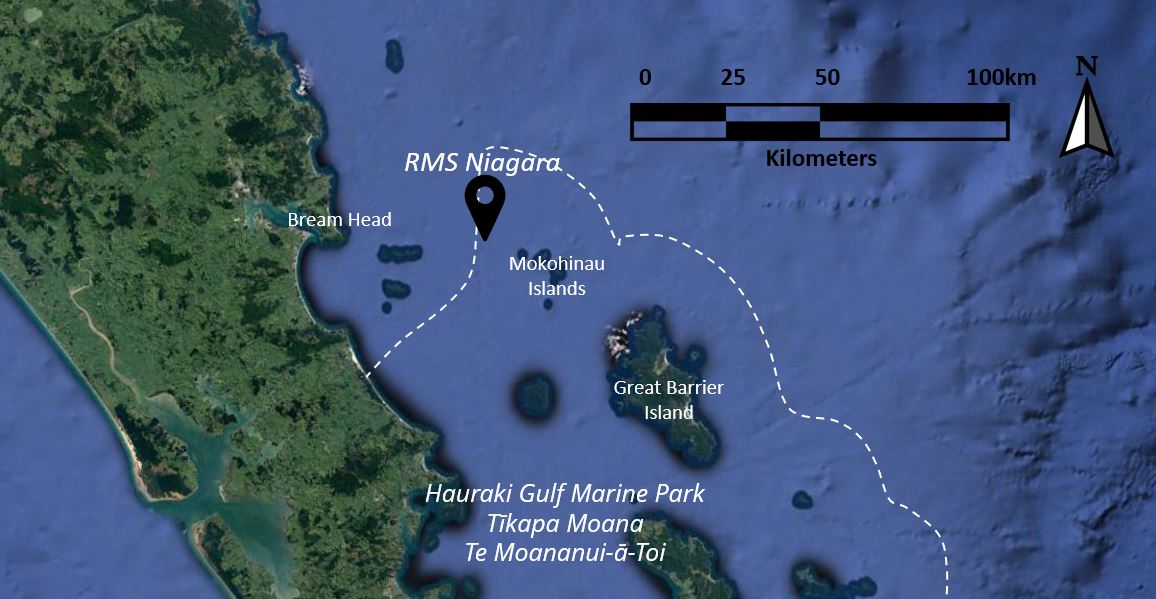
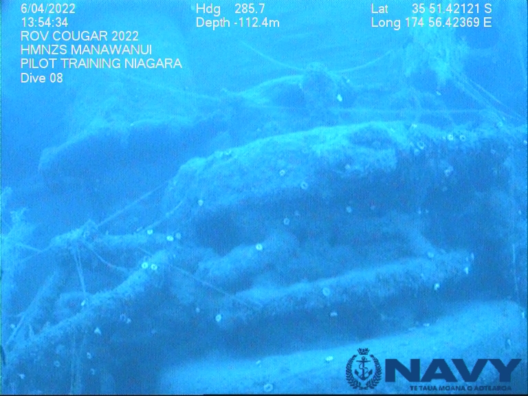
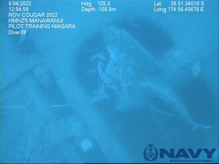
There has been several visits to the Niagara by a number of divers and remotely operated vehicles, to investigate the structure and observe the changes. The wreck is now home to a diversity of marine life but there is also much more that people want to know about the status of the sunken ship.
The most recent images from the wreck come from the New Zealand Defence Force, who conducted a training exercise in April 2022 to familiar their personnel with the HMNZS Manawanui’s state of the art remotely operated vehicle (ROV). They provided an updated survey of the condition of the wreck to Maritime NZ and the Whangarei harbour master as a result of this most recent ROV exploration and the photos below were part of the media release in their May newsletter.
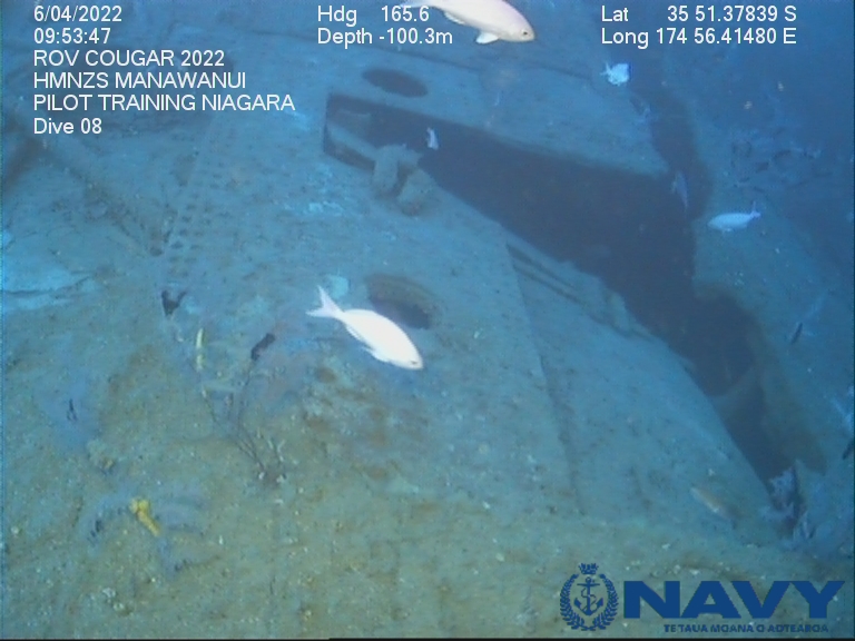
Photo Credit: New Zealand Defence Force
The wreck is not automatically afforded any legal protection and with the rapid progression of technical diving equipment and personal ROVs, the Niagara could potentially experience an increase in visitors and higher likelihood of modification/degradation. This was cited as one of the challenges of managing the Niagara’s threat to the ecosystem in this publication: Underwater Cultural Heritage in Aotearoa New Zealand: Challenges and Opportunities
“From my perspective as a maritime archaeologist, we need to also look at how this shipwreck is managed as a cultural heritage site as it is a timely reminder of how close WWII came to NZ.”
Kurt Bennet – Heritage New Zealand ~ Pouhere Taonga
Underwater explorer, Keith Gordon, author of Deep Water Gold – The Story of RMS Niagara – the Quest for New Zealand’s Greatest Shipwreck Treasure, is one of the biggest advocates in this situation, calling for the oil to be removed from the wreck for the past several years. He has gone to great lengths to explore and better understand the wreck and has been warning that “a ticking ecological time-bomb still lies unexploded in her bunkers.”
The biggest questions
People are still wondering; how much oil does Niagara still hold? Are her tanks strong enough to retain the oil, and if so for how much longer before they degrade to a point that they can’t contain the oil? Cost is one of the biggest barriers to resolving this potential threat, as pumping fuel oil from a wreck at that depth would be a very expensive exercise, but also – who’s job is it anyway? This situation spans across several jurisdictions – but falls under the responsibility of Maritime New Zealand.
Its known that the Niagara is leaking, and recent satellite imagery can detect the leak using multi-spectral optical imagery which provides insight into oil-type and thickness on the sea surface. However, the Niagara is not the only ship leaking oil into the pacific, there are wartime wrecks scattered all around the world’s oceans, at various levels of degradation, some of which are more at risk of collapsing and releasing oil than others.
The Major Projects Foundation is an organization that conducts research and uses a number of approaches to identify potentially polluting wrecks in the Pacific and mitigate environmental damage from them. There’s 3,800 of these wrecks which pose an environmental risk, 60 of which are considered ‘high priority’. The priority list includes the Niagara, and Major Projects is actively looking for funding to do further research on it.
“Its high priority status is due to knowledge that there is a high risk of further leakage and because the Niagara is in a seismically active and ecologically sensitive area.”
-Dr. Matt Carter, maritime archaeologist & Research Director for the Major Projects Foundation
Maritime NZ have an oil response plan and when put in perspective with regards to the abilty of other island nations in the Pacific to respond to a spill, we should feel confident that New Zealand is in a much better position than most. For now we will have to wait and see what further research will unveil about the Niagara and what she still stores within.