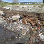
Sediment is identified as a major cause of degradation in marine habitats and a multifaceted response is proposed to reduce levels to those which support healthy marine habitats.
Objectives in the marine spatial plan aim to minimise erosion off the land, capture run off before reaching the marine environment and stabilise sediment already present.
The plan identifies catchment management plans, sediment traps, waterway management, sediment control practices, forestry harvesting codes, protection of erodible soils and restoration of seafloor habitats as important actions.
The proposed marine spatial plan looks to establish catchment nutrient load limits by 2020.
It proposes a targeted research programme in the Firth, including deployment of additional monitoring buoys, to understand causes and impacts of increasing dissolved nitrogen levels, oxygen depletion and acidification observed in the marine water column.
In the meantime there are to be no increases in nutrient loading from rural land use.
Urban-sourced pollutants such as heavy metals are targeted for reduction at source, through use of alternate materials, and prevention of entry into harbours through design and technology innovation.
The plan puts a 50 year time frame on achieving restored water quality in the Gulf.
The full text of the Sea Change – Tai Timu Tai Pari marine spatial plan is available here.